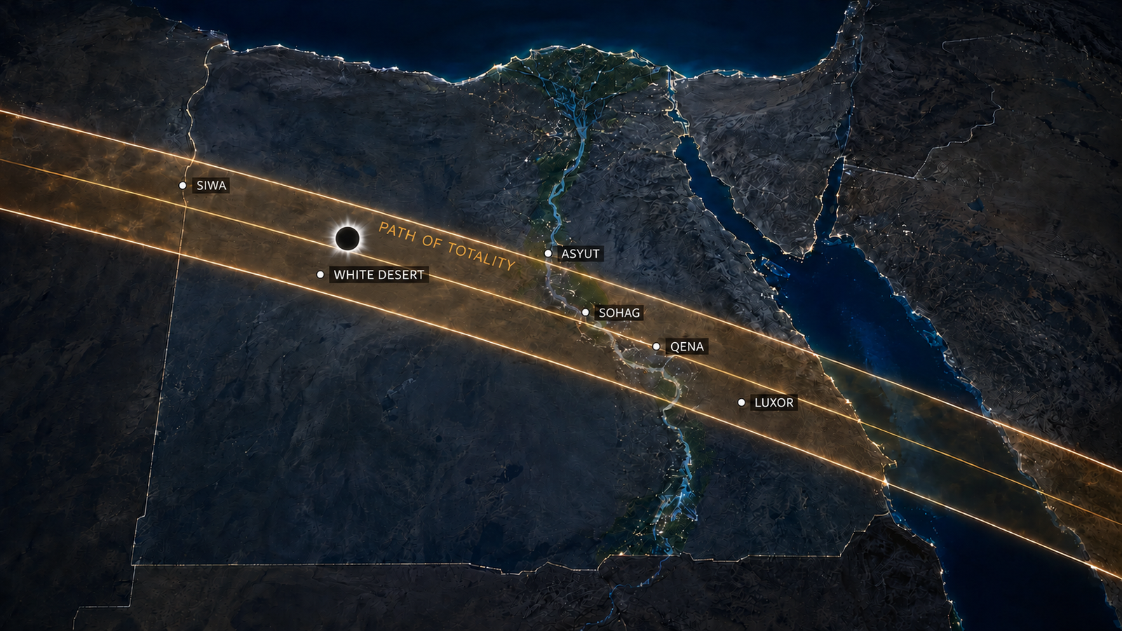
The 2027 solar eclipse Egypt map shows one of the most important astronomical corridors of the century crossing the country from the Western Desert to the Red Sea on Monday, August 2, 2027. Locations inside this narrow path will experience a total solar eclipse: the Moon will completely cover the Sun’s bright photosphere, the corona will become visible, and daylight will briefly fall into deep twilight.
Locations outside the path will see a partial eclipse, even when the coverage is extremely high.
That distinction is essential for travelers. Cairo, Alexandria, Hurghada, central Aswan and Farafra are examples of places expected to remain outside totality at representative city-center coordinates. Siwa Oasis, Bahariya Oasis, Asyut, Luxor, Qena and parts of the Marsa Alam region are examples of locations inside totality at suitable coordinates.
The path is not a line drawn through a few famous destinations. It is a corridor approximately 255 to 258 kilometers wide while crossing much of Egypt. Inside that corridor, duration changes according to the viewing location and distance from the centerline. Near the most favorable part of the path, totality can reach approximately 6 minutes 23 seconds.
This guide explains how to read the map, where the path crosses Egypt, which popular destinations are total or partial, why exact coordinates matter and how to choose a practical viewing site rather than simply chasing the longest number.
For the broader science, timing and travel overview, start with the complete guide to the 2027 total solar eclipse in Egypt.
Quick Answer: Where Is the Path of Totality in Egypt?
The 2027 path of totality enters Egypt from the west after crossing Libya, reaches the Siwa region, continues southeast across the Western Desert and Upper Egypt, crosses the Nile corridor near locations including Asyut, Sohag, Qena and Luxor, then continues through the Eastern Desert and reaches the Red Sea.
The path crosses a large part of central and southern Egypt, but not the entire country.
Representative locations inside totality include:
- Siwa Oasis.
- Bahariya Oasis and selected nearby Western Desert coordinates.
- Asyut.
- Parts of Sohag Governorate.
- Qena.
- Luxor.
- Selected parts of Aswan Governorate north of central Aswan city.
- Selected areas of the Eastern Desert.
- Marsa Alam and parts of the southern Red Sea coast.
Representative locations outside totality include:
- Alexandria.
- Cairo and Giza.
- Suez.
- Hurghada.
- Central Aswan city.
- Farafra at the common city reference point.
- Many standard White Desert tourism sites around Farafra.
The exact result must always be checked for the proposed GPS coordinate.
The Most Important Numbers on the NASA Map
NASA GSFC publishes northern limit, southern limit and centerline coordinates at two-minute intervals. While the shadow crosses Egypt, the path is exceptionally wide and totality remains close to its global maximum.
The main reference values are:
| Measurement | NASA reference value | Why it matters |
|---|---|---|
| Maximum global totality | About 6m 23.2s | This is the longest central duration, not a promise for every Egyptian site. |
| Greatest-duration coordinate | Approximately 26°49′N, 31°08′E | The longest predicted totality occurs in Egypt near this coordinate. |
| Greatest-eclipse coordinate | Approximately 25°30.3′N, 33°11.0′E | The Moon’s shadow axis passes closest to Earth’s center near this Egyptian coordinate. |
| Path width near greatest duration | About 257.2 km | The totality corridor is broad, but its edges remain decisive. |
| Path width near greatest eclipse | About 257.7 km | Many Egyptian regions lie inside the corridor, but not all cities do. |
| Sun altitude near greatest eclipse | About 81.7° | The Sun will be extremely high, reducing horizon blockage but complicating photography and shade placement. |
The “greatest eclipse” and “greatest duration” points are not identical. The first describes where the shadow axis passes closest to Earth’s center. The second describes where the central total phase lasts longest under the prediction model.
Both lie in Egypt for the 2027 event, which is one reason the country is central to global eclipse planning.
Read why the 2027 eclipse can last more than six minutes for the orbital explanation.
How to Read the 2027 Eclipse Map
A proper eclipse map contains more information than a shaded band.
Northern Limit
The northern limit marks the upper edge of totality. A location just north of that boundary sees a partial eclipse. A location just inside it sees totality, but the duration may be very short.
Southern Limit
The southern limit marks the lower edge. The same rule applies: crossing the boundary changes the local event from total to partial.
Centerline
The centerline runs through the middle of the path. Totality is generally longer near it than near the boundaries, although the exact greatest-duration point also depends on movement along the global path.
Time Lines
NASA’s map includes lines showing the position of the shadow at time intervals. These help explain why western Egypt experiences the central phase earlier than Upper Egypt and the Red Sea.
Partial-Eclipse Region
The much larger region outside the central band still sees the Moon cover part of the Sun. Cairo and Alexandria will see a deep partial eclipse, but the corona will not become visible and eclipse glasses must remain on throughout.
See the detailed 2027 solar eclipse times in Egypt by city for the timing comparison.
The Path Across Egypt from West to East
The shadow reaches Egypt from Libya and moves generally east-southeast. The following geographic sequence is useful for understanding the countrywide route.
1. Siwa Oasis and Western Egypt
Siwa Oasis is one of the first well-known Egyptian destinations inside the totality path.
At a representative Siwa coordinate, totality lasts approximately 5 minutes 31 to 5 minutes 33 seconds, with maximum eclipse near 12:45 pm local summer time. The oasis is inside totality, but it is not close to the global greatest-duration point.
Siwa offers:
- A recognizable oasis destination.
- Open desert landscapes.
- A total phase longer than most modern eclipses.
- A distinctive cultural and geographic setting.
- Potential separation from Nile Valley crowds.
Its operational challenges include:
- Long road transfers.
- Limited accommodation compared with major tourism cities.
- August heat.
- Vehicle and fuel planning.
- Medical and communications support.
- Possible congestion on limited approach roads.
The full Siwa Oasis eclipse guide compares the astronomy and logistics with other Egyptian locations.
2. Bahariya Oasis and the Western Desert
The path continues across the Western Desert toward Bahariya.
Representative Bawiti/Bahariya coordinates lie securely inside totality and can receive approximately 6 minutes 17 seconds, depending on the exact point and calculation model. That places Bahariya among the strongest practical candidates for a Cairo-accessible Western Desert camp.
Bahariya’s strategic advantages include:
- A long total phase.
- Road connection from Cairo.
- Existing oasis accommodation and tourism operations.
- Access to Western Desert landscapes.
- Space for a managed viewing field outside dense urban areas.
- The possibility of combining the eclipse with Black Desert and White Desert experiences.
The critical wording is “Bahariya-based Western Desert camp,” not a blanket claim that every White Desert location lies inside totality.
A final camp may be north, south or east of Bawiti. Its exact duration should be published only after the coordinates, land access and operational layout are fixed.
The air-conditioned eclipse camp guide explains how cooling, shade and an open viewing field should work together.
3. Farafra and the Standard White Desert Region
Farafra is a warning against relying on tourism names.
At a representative Farafra coordinate, the August 2 eclipse is a very deep partial eclipse with magnitude around 0.994, not totality. Almost all of the Sun’s diameter is covered, yet a narrow segment of the photosphere remains visible.
That remaining sunlight matters:
- The corona is not revealed as during totality.
- Eclipse glasses remain necessary.
- There is no safe naked-eye phase.
- The environmental transformation is less dramatic.
- The site cannot honestly be sold as a total-eclipse viewing point.
The White Desert is a broad protected and tourism region. Some travel itineraries use “White Desert” as a general product name covering Bahariya, the Black Desert, Crystal Mountain, Agabat and Farafra-area landscapes. The astronomical map does not follow marketing terminology.
The correct approach is to separate:
- The verified eclipse viewing field.
- The camp location.
- Bahariya Oasis.
- White Desert excursions.
- Farafra and the standard protected-area route.
Read can you see the 2027 total eclipse from Egypt’s White Desert? for the dedicated coordinate-based analysis.
4. Asyut and the Central Nile Corridor
The shadow crosses the Nile Valley near Asyut, which lies inside totality at representative city coordinates.
Asyut receives approximately six minutes of totality and reaches maximum eclipse around 1:00 pm local time. It is close to the western Egyptian greatest-duration region.
Astronomically, Asyut is highly favorable. Operationally, planners must evaluate:
- Urban density.
- Agricultural land.
- Road access.
- Buildings and trees.
- Legal access to open land.
- Crowd concentration.
- Hotel capacity.
- Heat management.
- The ability to create a controlled viewing field.
A city inside totality is not automatically a good event site. The viewing field should be open, permitted, accessible and large enough for vehicles, guests, tripods and emergency movement.
5. Sohag and the Greatest-Duration Region
NASA places the point of greatest duration at approximately 26°49′N, 31°08′E, where totality reaches about 6 minutes 23.2 seconds.
This coordinate lies in Upper Egypt near the central Nile corridor rather than in the familiar Farafra White Desert tourism zone.
The existence of this point creates a common planning mistake: assuming the exact longest coordinate is automatically the best traveler location.
A site at or near greatest duration may still have disadvantages:
- Difficult land access.
- Agricultural obstruction.
- Local roads unsuitable for large groups.
- Limited toilets or shade.
- No approved event space.
- Proximity to settlements.
- Security or permit requirements.
- A poor vehicle departure plan.
The difference between 6 minutes 23 seconds and 6 minutes 17 seconds may be only a few seconds, while the difference in guest comfort and operational safety can be enormous.
The best site should optimize the whole experience rather than totality alone.
6. Qena
Qena lies inside the totality corridor and can receive more than six minutes at suitable coordinates.
The region may offer alternatives to central Luxor while remaining near major Upper Egyptian attractions and roads.
Potential advantages include:
- Long totality.
- Nile Valley access.
- Proximity to Dendera and other cultural sites.
- Multiple possible open-land locations.
- A high Sun.
Potential limitations include:
- Agricultural and urban obstruction.
- Competition for transport and accommodation.
- Permits.
- Heat.
- Public crowd concentration.
- Limited control at famous attractions.
No archaeological site should be advertised as an eclipse venue unless the relevant authority has confirmed access and event rules.
7. Luxor
Luxor is one of the strongest and most marketable totality destinations in Egypt.
At representative Luxor coordinates, totality lasts approximately 6 minutes 22 seconds, close to the global maximum. Maximum eclipse occurs around 1:05 pm local time.
Luxor offers:
- Established hotel capacity.
- An international tourism identity.
- Airport access.
- Nile cruises.
- Major ancient monuments.
- Professional tourism services.
- Extremely long totality.
It may also face:
- Very high demand.
- Large organized groups.
- Hotel price pressure.
- Traffic.
- Restrictions around heritage areas.
- Urban and agricultural obstructions.
- Less control over public viewing spaces.
- Intense midday heat.
The complete Luxor eclipse guide explains why excellent astronomy does not automatically solve crowd and site-control issues.
8. Aswan Governorate
Aswan is another example of why city and governorate must be separated.
Central Aswan city is expected to see a very deep partial eclipse with magnitude around 0.996 at a common city reference point. The Sun is almost fully covered, but the city center remains just outside totality.
Parts of the wider Aswan Governorate, especially farther north, can lie inside the totality path. A short geographic shift can therefore change the eclipse type.
A responsible travel page should never say simply:
- “Aswan is total,” or
- “Aswan is partial.”
Instead, it should state the exact coordinate or named viewing field.
The dedicated article is Aswan inside the 2027 eclipse path? explains this boundary issue in detail.
9. Eastern Desert and Greatest Eclipse
NASA places greatest eclipse at approximately 25°30.3′N, 33°11.0′E in Egypt’s Eastern Desert.
At that moment:
- The Sun is approximately 81.7 degrees above the horizon.
- The path is approximately 257.7 kilometers wide.
- Central duration is approximately 6 minutes 22.6 seconds.
The Eastern Desert may offer extremely strong astronomical geometry and open horizons, but it can be operationally demanding.
Questions include:
- Is the road suitable for buses and support vehicles?
- Is the land legally accessible?
- Can emergency vehicles reach the field?
- Is communication coverage available?
- Can toilets, water, shade and cooling be delivered?
- Is the terrain safe for walking and tripods?
- Is a same-day resort transfer realistic?
- Is there a backup location?
Remote open land should not be confused with easy land.
10. Hurghada and the Northern Red Sea
Hurghada is outside the path of totality at representative city coordinates.
The city sees a deep partial eclipse, with magnitude around 0.980 and maximum near 1:05 pm. It does not receive a total phase.
This matters because many travelers search for “Red Sea eclipse” without distinguishing the long coastline.
Hurghada offers substantial resort capacity and airport access, but guests who stay in the city and want totality would need an organized transfer south or southwest to a verified point inside the path.
The transport plan must consider:
- Departure time.
- Road capacity.
- Heat.
- Toilet stops.
- Equipment.
- Return traffic.
- The distance from the path boundary.
- The risk of arriving late.
11. Marsa Alam and the Southern Red Sea
Representative Marsa Alam coordinates lie inside totality.
The local total phase is approximately 5 minutes 27 to 5 minutes 28 seconds, with maximum eclipse around 1:10 or 1:11 pm.
Marsa Alam may combine:
- Resort accommodation.
- Airport access.
- Red Sea scenery.
- A verified total phase at suitable coordinates.
- A later maximum than western Egypt.
- Opportunities for diving or coastal extensions.
However, “Marsa Alam” can describe a large coastal stretch. A resort tens of kilometers from the town reference may have different circumstances.
The exact hotel or inland viewing field must be checked individually.
The Hurghada vs Marsa Alam eclipse comparison explains why one is partial and the other can be total.
City and Region Comparison Table
| Location | Representative local type | Approximate central experience | Main planning message |
|---|---|---|---|
| Alexandria | Partial | No totality | Good for partial viewing only; totality requires travel. |
| Cairo and Giza | Partial | No totality | Use as arrival gateway, then transfer to the path. |
| Siwa Oasis | Total | About 5m 33s | Strong oasis option with long road logistics. |
| Bahariya Oasis | Total | About 6m 17s at representative coordinates | Strong Cairo-accessible Western Desert base. |
| Farafra | Deep partial | Magnitude around 0.994 | Do not equate standard White Desert tourism sites with totality. |
| Asyut | Total | About 6m 05–07s | Excellent duration; open-site logistics still required. |
| Luxor | Total | About 6m 22s | Near-maximum duration with major tourism infrastructure and crowd risk. |
| Qena | Total | About 6m 10s | Long totality and possible alternative to central Luxor. |
| Aswan city | Deep partial | Magnitude around 0.996 | Parts of the governorate may be total; use exact coordinates. |
| Hurghada | Partial | Magnitude around 0.980 | Resort base outside totality; transfer required. |
| Marsa Alam | Total at representative coordinates | About 5m 28s | Verify each resort and field separately. |
For a scored destination analysis, read the best place in Egypt to watch the 2027 solar eclipse.
Why Being Inside the Path Is More Important Than Percentage Coverage
A traveler may see 99.4 or 99.6 percent coverage on an app and assume that totality adds only the remaining fraction.
That is incorrect.
During a deep partial eclipse:
- A segment of the photosphere remains visible.
- The Sun remains unsafe to view without protection.
- The corona remains hidden by direct sunlight.
- The sky does not darken in the same way.
- The diamond-ring transition into full totality does not occur.
- The environmental change is reduced.
Totality is a threshold. The photosphere must disappear completely.
This is explained in the total vs partial vs annular eclipse comparison.
How Close to the Centerline Should You Be?
The centerline generally offers longer totality, but a professional site does not need to sit exactly on it.
A strong viewing field can be several kilometers away and still receive a totality duration close to the maximum for the region.
The practical decision should balance:
- Duration.
- Road quality.
- Land permission.
- Terrain.
- Horizon.
- Group capacity.
- Emergency access.
- Shade and cooling.
- Toilets.
- Communications.
- Crowd control.
- Ability to remain overnight.
- Distance from the path boundary.
Avoid sites close to the northern or southern limit unless there is a deliberate scientific reason. Near-edge locations may produce interesting Baily’s beads, but totality becomes shorter and path uncertainty becomes more important.
Lunar-Limb Corrections and Path Uncertainty
NASA’s standard path is calculated using the Moon’s center of mass. The lunar edge is not smooth; mountains and valleys affect the exact instant when the final sunlight disappears and returns.
NASA notes that detailed lunar-limb corrections may:
- Shift the northern or southern limits by roughly 1 to 3 kilometers.
- Change local duration by roughly 1 to 3 seconds.
- Shift the exact greatest-duration point by roughly 10 to 20 kilometers.
These refinements do not move Luxor to Cairo or turn a clearly partial city into a central totality location. They matter most near a boundary and when advertising exact seconds.
For practical planning, choose a viewing point comfortably inside the path, avoid false precision near the boundaries and confirm exact coordinates closer to the event.
How the High Sun Changes the Viewing Field
The Sun will be extremely high during the central phase across Egypt, reaching more than 80 degrees altitude near the strongest part of the path.
This helps because:
- Mountains and low buildings are less likely to block it.
- Horizon haze matters less.
- A wide flat field can offer an unobstructed view.
It complicates operations because:
- Guests must look almost overhead.
- Camera lenses need steep elevation.
- Tripod heads may collide with legs or cables.
- Shade roofs can accidentally block the Sun.
- People may stand in front of tilted equipment.
- Heat exposure is strongest around midday.
A good camp places an air-conditioned rest area and shade beside the observation field, not over the central viewing line.
Weather, Dust and the Map
The eclipse map proves where totality occurs. It does not prove that the sky will be clear.
A viewing decision should combine path geometry with:
- Historical cloud patterns.
- Dust and wind.
- Local haze.
- Coastal humidity.
- Urban pollution.
- Mobility.
- Road and terrain conditions.
- Short-range forecasts close to eclipse day.
Western Desert and Upper Egypt locations may have favorable dry-season climatology, but no operator can guarantee visibility.
The honest promise is a verified path position, experienced local operations and realistic weather communication.
Path Geometry vs Guest Safety
The longest possible coordinate can be operationally unsuitable.
August desert conditions can be demanding. A safe viewing plan needs:
- Air-conditioned recovery space.
- Shade.
- Cold water.
- Electrolytes.
- Meals.
- Toilets.
- Medical support.
- Trained drivers.
- Communications.
- Backup power.
- Controlled lighting.
- Emergency vehicle access.
- A staged departure plan.
The White Desert summer safety warning explains why normal winter camping assumptions do not apply to an August eclipse.
Western Desert vs Nile Valley
The path offers two broad destination styles.
Nile Valley
Strengths:
- Hotels.
- Airports or rail links.
- Famous cultural attractions.
- Established tourism supply.
- Long totality in Asyut, Qena and Luxor.
Challenges:
- Crowds.
- Traffic.
- Agricultural and urban obstruction.
- Limited control around public monuments.
- Competition for rooms and vehicles.
Western Desert
Strengths:
- Open horizons.
- Lower urban density.
- More control in a private camp.
- Long totality near Bahariya-based coordinates.
- A distinctive landscape.
- Multi-day group preparation.
Challenges:
- Heat.
- Remote access.
- Dependence on vehicles and local knowledge.
- Water and fuel planning.
- Medical and communications requirements.
- Permits and land access.
Read the complete Western Desert vs Nile Valley eclipse comparison.
How to Verify a Tour Operator’s Map Claim
Before booking, ask the operator for:
- The intended viewing region.
- Whether the final GPS coordinate is confirmed.
- Local totality duration at that coordinate.
- Distance from the path boundary.
- Source of the calculation.
- Date the calculation was last checked.
- Whether the camp and viewing field are in the same place.
- Whether a transfer is required on eclipse morning.
- Land access or permit status.
- Cooling and medical plan.
- What happens if the site changes.
- Whether the exact coordinate will be shared before travel.
A credible operator may withhold a precise private camp coordinate from a public page for operational reasons, but should still explain the verification method and provide enough information for the customer to understand that the field lies inside totality.
Frequently Asked Questions
Where does the 2027 eclipse path cross Egypt?
It crosses western Egypt near Siwa, continues across the Western Desert and Upper Egypt, crosses the Nile corridor and Eastern Desert, then reaches the Red Sea.
Is Cairo in the path of totality?
No. Cairo sees a deep partial eclipse.
Is Alexandria in totality?
No. Alexandria is outside the totality path.
Is Siwa inside totality?
Yes, at representative Siwa coordinates. Local totality is approximately 5 minutes 33 seconds.
Is Bahariya inside totality?
Representative Bahariya and Bawiti coordinates are inside totality, but the final camp must be calculated independently.
Is the White Desert inside totality?
The name covers a broad region. Common Farafra-area coordinates are outside totality, while a Bahariya-based Western Desert camp may be inside it. Use exact GPS coordinates.
Is Luxor inside totality?
Yes. Representative Luxor coordinates receive approximately 6 minutes 22 seconds.
Is Aswan inside totality?
Central Aswan city is outside totality, but parts of the wider governorate can lie inside the path.
Is Hurghada inside totality?
No, not at the representative city coordinate.
Is Marsa Alam inside totality?
Representative Marsa Alam coordinates lie inside totality, but each resort or viewing field must be checked.
Where is the longest totality in Egypt?
NASA places greatest duration near 26°49′N, 31°08′E, with approximately 6 minutes 23.2 seconds.
Is the centerline always the best place?
Not automatically. Access, safety, heat, crowding and legal land use may make another interior-path site better.
How wide is the path in Egypt?
It is roughly 255 to 258 kilometers wide across the strongest part of the Egyptian route.
Can the path change before 2027?
The broad path is stable. Detailed lunar-limb calculations can shift the edges by a few kilometers and adjust durations by seconds.
Can an operator guarantee clear skies?
No. The operator can verify totality and prepare logistics, but weather cannot be guaranteed.
Sources and Further Reading
- NASA GSFC path table for the August 2, 2027 total solar eclipse
- NASA GSFC interactive 2027 eclipse map
- NASA Science future eclipse overview
- NASA eclipse-viewing safety guide
- Timeanddate Egypt eclipse map as a supplementary local reference
Final Takeaway
The 2027 path of totality crosses a broad corridor through Egypt, but not every famous destination lies inside it.
Siwa, Bahariya, Asyut, Luxor, Qena and representative Marsa Alam locations are inside totality. Cairo, Alexandria, Hurghada, central Aswan and Farafra are partial at common reference coordinates.
The strongest eclipse plan uses the map as the first filter, not the final decision. After entering the path, travelers must compare duration, weather, heat, access, permits, crowds and camp operations.
Explore the Egypt eclipse tour packages for 2027 or check availability for a verified Western Desert viewing plan.